Indepth Map and Multi Editor FAQ
Lets begin (by saying punt is amazing for making these tools, and allowing the public map builders to use them)
Step 1 - Installation
First you will need the following files which you can get here
http://worldmaker.ryandor.com/download.php
-Map Editor
-Multi Editor
-QT 4.1.2 *.dll files
-Mingw.dll
-Palette.xml (attached to this post)
Extract them all into the same directory,. when installed load WFmulti first
and well go over that...
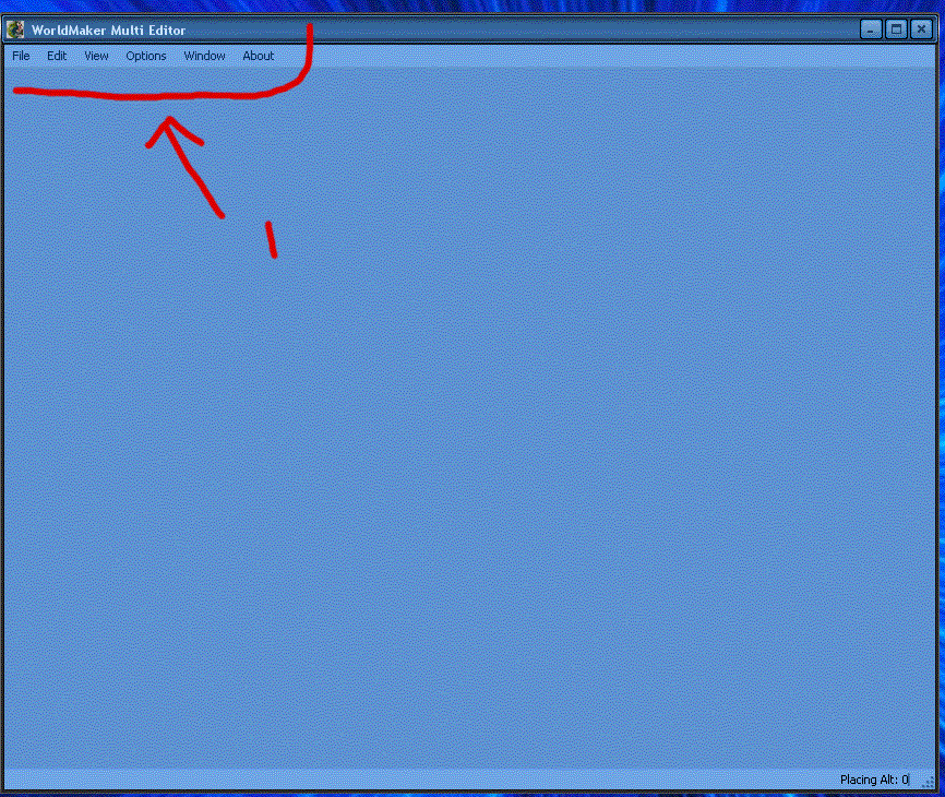
File -
Under File the following things will Appear.
New - Allows you to begin creation of a new Multi
Open - Allows you to open a saved multi
Close - Allows you to close the current multi project
----------------------------------------------------------
Save - Allows you to save (will act as save as if you havent
selected a filename yet.)
Save As - Allows you to save and select a name for the file
----------------------------------------------------------
Export - Allows you to Export your creation into. your
multi.mul file. this of course is also the file
that ultima receives its data for your classic
houses. so anything you put in here,. can be
accessed from the game.
---------------------------------------------------------
Capture - Allows you to save your current work to a BMP file.
--------------------------------------------------------
Exit - Exits the program
Edit
Select all - This will allow you to select all of your items in your
creation.
-----------------------------------------------------------
Undo - Un-does the last thing you did
Redo - Re-does the last undo.
-----------------------------------------------------------
Cut - Removes the current tile selection, but allows you to place
it again with paste.
Copy - Leaves the current tile selections, but allows for duplication
and placement with paste.
Paste - Allows you to Place a copy or cut.
------------------------------------------------------------
Delete - Allows you to delete current selection of tiles.
Insert - Allows you to add an item from a Mlt file, A multi.mul entry
or an Item by its ID.
------------------------------------------------------------
Adjust - Allows you to Adjust the location of the tile, aswell as
the altitude in 1 Z increments.
------------------------------------------------------------
Altitude - Allows you to set the altitude of the current tile selection
Hue - Allows you to set the Hue (color) of the current tile selection
Visable - Allows you to set weither the current tile selection is visable
or not.
Veiw
Invisible - Allows you to see the Invisible
--------------------------------------------------------------
Grid - Will display a Tile placement Grid
--------------------------------------------------------------
Clipper - Allows you set the altitude at which you are veiwing
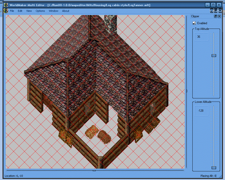
You see the clipper tool is enabled.
also its set at top 36,. watch what happens when i lower it.
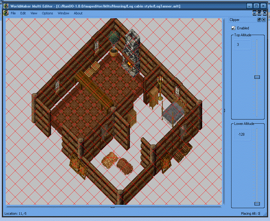
you see now its set at 3. that meens it wont show any tiles (items) that are made at an altitude higher then 3. the roof is still there. but its been removed for easy editing inside the structure. you can also do this the opposite way. just showing things higher then an altitude of 3 using the second bar,. you can adjust it anyway you need, for veiwing.
--------------------------------------------------------------
Palette - Allows you to see the palette from which you can
See items. heres a look at the pallette.
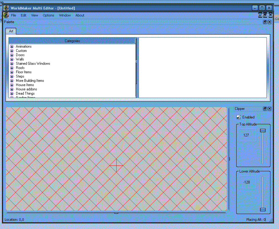
From that list you can select whatever it is you wish to place in your multi.
Options
Goto - Allows you to change location by X, Y cords
---------------------------------------------------------
Placing Altitude - Allows you to lock the altitude for new tiles
you place (building second floors roofs etc)
---------------------------------------------------------
Scale - Allows you to zoom out from the surface,
---------------------------------------------------------
Grid line color - Allows you to set the color of your grid
---------------------------------------------------------
Mul locations - Important, you must set the location of you
*.mul files (your ultima directory basically)
to be able to do anything.
Window
Tile - Allows you to arrange your window in a tile formation
---------------------------------------------------------
Cascade - Allows you to arrange your windows in a cascade formation
---------------------------------------------------------
Untitled - Whatever you want them arranged like (custom basically)
About
Will give you some information about build,etc of the program
Map Editor
After Explaining multi editor, map editor will be very simple to explain
since its almost the same setup as you can see here.. i will document the
changes only anything that isnt documented please refer to the multi editor explination (things like grid line color etc)..
ok differences.
File
Open - will now allow you to only open, the map, example. felluca
trammel etc (your custom map will be whichever you have
replaced your map with if you remade felluca then selecting
felluca will display your map instead)
Save - Will automatically save your work to the Mul file of the map
you are working on.
Capture - Will capture a bmp file of whats currently showing on your
map..
Edit
Mode - This will allow you to select between editing art, and terrain
so map.mul and static0.mul and staidx0.mul.
Insert - will also now allow you to inport your .mlt files from multi
editor to the map. (known issues ive had it wont load it
onto the map, the way i fixed it. is that in multi editor
i export it to a multi.mul entry, then i import from multi.mul
in map editor. but you only need to do this is it wont let you
import from a mlt file)
VeiwMode - this will allow you to select different veiw modes. for example
Terrain if checkmarked shows terrain if not. it removes the
terrain (good for seeing subterrainen areas) Art if check
marked shows art, if not checkmarked. art dissapeers,
flat. changes the editing mode to more like world forge (
though you cant lock your terrain altitude in wfmap. so
remember to set your altitude for all tiles, this mode is good
for seeing areas usually blocked by a high mountain or hill.)
Radar - Shows you a over head map of the world like this.
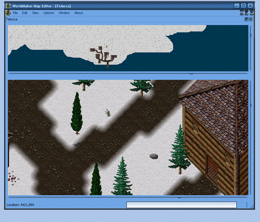
you can double click on the rader map and it will move you to that location
in the editing window..Options
Diff save - allows you to save your changes to the Diff files.
Much like the changes of Felluca > Trammel.
In Conclusion.
Punt did a god-like job making these tools for us. they are forsure
a dream come true for map editors. i would recommend them for making
dungeons, building towns, etc. (although because you cannot lock altitude
in map editor yet i would still recommend using worldforge for altitude editing, other then that if you want to cut down development time of your
map into a quarter. you need these programs)
This has been another Mogbert FAQ
Any questions or concerns PM me.
If you liked the post please ++ karma me.
If you dont and you -- karma me, please leave your concern and your
name so i can address the concerns you have thanks alot..
Lets begin (by saying punt is amazing for making these tools, and allowing the public map builders to use them)
Step 1 - Installation
First you will need the following files which you can get here
http://worldmaker.ryandor.com/download.php
-Map Editor
-Multi Editor
-QT 4.1.2 *.dll files
-Mingw.dll
-Palette.xml (attached to this post)
Extract them all into the same directory,. when installed load WFmulti first
and well go over that...
File -
Under File the following things will Appear.
New - Allows you to begin creation of a new Multi
Open - Allows you to open a saved multi
Close - Allows you to close the current multi project
----------------------------------------------------------
Save - Allows you to save (will act as save as if you havent
selected a filename yet.)
Save As - Allows you to save and select a name for the file
----------------------------------------------------------
Export - Allows you to Export your creation into. your
multi.mul file. this of course is also the file
that ultima receives its data for your classic
houses. so anything you put in here,. can be
accessed from the game.
---------------------------------------------------------
Capture - Allows you to save your current work to a BMP file.
--------------------------------------------------------
Exit - Exits the program
Edit
Select all - This will allow you to select all of your items in your
creation.
-----------------------------------------------------------
Undo - Un-does the last thing you did
Redo - Re-does the last undo.
-----------------------------------------------------------
Cut - Removes the current tile selection, but allows you to place
it again with paste.
Copy - Leaves the current tile selections, but allows for duplication
and placement with paste.
Paste - Allows you to Place a copy or cut.
------------------------------------------------------------
Delete - Allows you to delete current selection of tiles.
Insert - Allows you to add an item from a Mlt file, A multi.mul entry
or an Item by its ID.
------------------------------------------------------------
Adjust - Allows you to Adjust the location of the tile, aswell as
the altitude in 1 Z increments.
------------------------------------------------------------
Altitude - Allows you to set the altitude of the current tile selection
Hue - Allows you to set the Hue (color) of the current tile selection
Visable - Allows you to set weither the current tile selection is visable
or not.
Veiw
Invisible - Allows you to see the Invisible
--------------------------------------------------------------
Grid - Will display a Tile placement Grid
--------------------------------------------------------------
Clipper - Allows you set the altitude at which you are veiwing
You see the clipper tool is enabled.
also its set at top 36,. watch what happens when i lower it.
you see now its set at 3. that meens it wont show any tiles (items) that are made at an altitude higher then 3. the roof is still there. but its been removed for easy editing inside the structure. you can also do this the opposite way. just showing things higher then an altitude of 3 using the second bar,. you can adjust it anyway you need, for veiwing.
--------------------------------------------------------------
Palette - Allows you to see the palette from which you can
See items. heres a look at the pallette.
From that list you can select whatever it is you wish to place in your multi.
Options
Goto - Allows you to change location by X, Y cords
---------------------------------------------------------
Placing Altitude - Allows you to lock the altitude for new tiles
you place (building second floors roofs etc)
---------------------------------------------------------
Scale - Allows you to zoom out from the surface,
---------------------------------------------------------
Grid line color - Allows you to set the color of your grid
---------------------------------------------------------
Mul locations - Important, you must set the location of you
*.mul files (your ultima directory basically)
to be able to do anything.
Window
Tile - Allows you to arrange your window in a tile formation
---------------------------------------------------------
Cascade - Allows you to arrange your windows in a cascade formation
---------------------------------------------------------
Untitled - Whatever you want them arranged like (custom basically)
About
Will give you some information about build,etc of the program
Map Editor
After Explaining multi editor, map editor will be very simple to explain
since its almost the same setup as you can see here.. i will document the
changes only anything that isnt documented please refer to the multi editor explination (things like grid line color etc)..
ok differences.
File
Open - will now allow you to only open, the map, example. felluca
trammel etc (your custom map will be whichever you have
replaced your map with if you remade felluca then selecting
felluca will display your map instead)
Save - Will automatically save your work to the Mul file of the map
you are working on.
Capture - Will capture a bmp file of whats currently showing on your
map..
Edit
Mode - This will allow you to select between editing art, and terrain
so map.mul and static0.mul and staidx0.mul.
Insert - will also now allow you to inport your .mlt files from multi
editor to the map. (known issues ive had it wont load it
onto the map, the way i fixed it. is that in multi editor
i export it to a multi.mul entry, then i import from multi.mul
in map editor. but you only need to do this is it wont let you
import from a mlt file)
VeiwMode - this will allow you to select different veiw modes. for example
Terrain if checkmarked shows terrain if not. it removes the
terrain (good for seeing subterrainen areas) Art if check
marked shows art, if not checkmarked. art dissapeers,
flat. changes the editing mode to more like world forge (
though you cant lock your terrain altitude in wfmap. so
remember to set your altitude for all tiles, this mode is good
for seeing areas usually blocked by a high mountain or hill.)
Radar - Shows you a over head map of the world like this.
you can double click on the rader map and it will move you to that location
in the editing window..Options
Diff save - allows you to save your changes to the Diff files.
Much like the changes of Felluca > Trammel.
In Conclusion.
Punt did a god-like job making these tools for us. they are forsure
a dream come true for map editors. i would recommend them for making
dungeons, building towns, etc. (although because you cannot lock altitude
in map editor yet i would still recommend using worldforge for altitude editing, other then that if you want to cut down development time of your
map into a quarter. you need these programs)
This has been another Mogbert FAQ
Any questions or concerns PM me.
If you liked the post please ++ karma me.
If you dont and you -- karma me, please leave your concern and your
name so i can address the concerns you have
thanks alot..